As much as we love hiking, there's just something special about a waterfall hike. It feels like nature's beautiful reward for burning a little boot leather on the hiking trails. Michigan is loaded with state parks and national forests filled with beautiful waterfall day hikes. It's not too surprising, considering it's hard to get more than a few miles away from any body of water in the Great Lakes State. Most of Michigan's waterfalls are easy day hikes. And many of them are clustered in the same areas, allowing hikers the chance to tackle several in a day if they choose. I had a day in Michigan's Upper Peninsula, where I visited five or six all in the same day, each with something else to offer in terms of terrain and view.
Today, we'll highlight some of our favorite day hikes that you should consider on your next trip to Michigan's U.P. We focused exclusively on the U.P. because the lower peninsula does not have many waterfalls to speak of, and none is of any sizable height. Plus, there's just more vast wilderness to enjoy in the U.P.
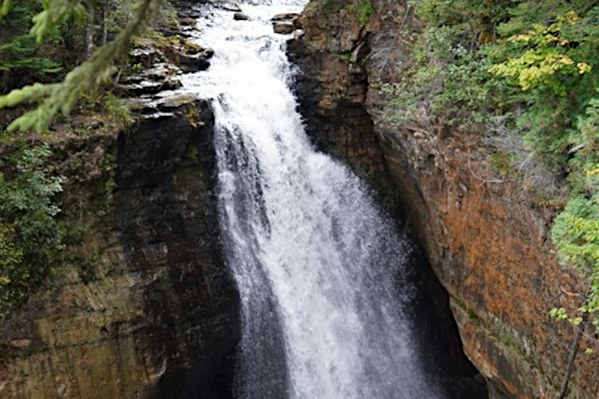
Mishicot Falls, Norway, Michigan

Mishicot Falls may be small, but the hike is breathtaking on the Michigan-Wisconsin border. Photo by Travis Smola
I'm going to start this list off with a smaller waterfall that's a bit of a hidden gem among the state's waterfall hikes. One could argue the 8-foot Mishicot Falls are more of a rapids, located along the Menominee River as it forms the border between Wisconsin and Michigan. However, the tucked-away nature of the trail, the Piers Gorge Scenic Hiking Trail, means it gets few visitors. When I hiked this section in August, I saw maybe three or four other people the whole time. The falls and rapids are less than half a mile down the trail from the parking lot.
Speaking of parking, the lot for this one is kind of hard to find. In Norway, take U.S. 8 south toward the Wisconsin border, and just before you cross the bridge, hang a right onto Piers Gorge Road heading west. Take that just over a mile, and the parking lot is at the end of the road. From there, it's a short walk through a lush forest to the riverside. You'll hear the rushing water long before you see the falls. Keep heading up, and eventually you'll see the largest drop of the Mishicot. This is a great hike that's only about a 3-mile detour from U.S. 2. Many people miss it because it's not heavily advertised, and most people seem to be rushing their way either west to Iron Mountain or east to Escanaba. It's well worth the short detour.
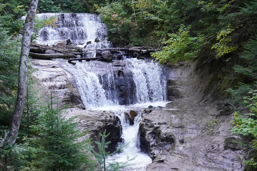
Laughing Whitefish Falls, Dorsey
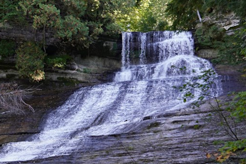
Travis Smola
This one is a bit off the beaten path, which we think is a good thing because that means it doesn't get nearly the crowds that other waterfalls in the area do. Located about 30 miles from Munising, it's easy to think you've gotten lost as the road to this one is gravel with a small parking lot. The trail to the falls is roughly half a mile, so you're looking at about a mile round trip. It's mostly flat, hard-packed gravel until you get to the falls. The path there is not the most scenic, but the end reward is worth it.
At the end of the trail, a boardwalk puts you at the top of the falls where the Whitefish River gently cascades down a limestone cliff some 100 feet to the bottom like a giant natural waterslide. The view from the top is nice, but to truly appreciate this one, you'll need to take the 150 or so steps on the wooden boardwalk to the bottom for the full effect. The easiest way to get to the falls is to take M-28 south out of Munising and then hit M-94 west for approximately 26 miles to the turnoff, which is a dirt road but it is well marked on M-94. Make sure you top off your gas tank and buy some snacks before you head out there. This is a remote area, and there is little civilization between the falls and Marquette. These falls are open year-round, but the road and parking lot are not plowed in winter; so unless you've got a heavy-duty vehicle, you might want to wait for the spring thaw.
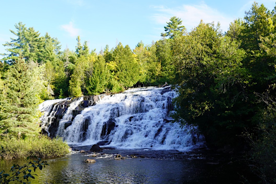
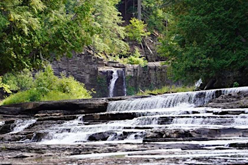
Bond Falls, Paulding
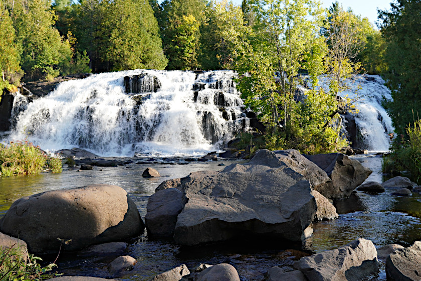
Travis Smola
This waterfall has my vote for the single most beautiful in Michigan. Bond Falls is located on the middle branch of the Ontonagon River. This waterfall cascades in multiple spots, with the largest drops being about 50 feet high. Seriously, this multi-tiered waterfall looks as if it was ripped straight from the pages of a book of fairy tales. It's easy to lose yourself in the magic of this place. This waterfall does get some crowds. I recommend going in the early morning or in the evening when it is not as busy.
The falls themselves are a short, .20-mile hike from a well-maintained parking area with a picnic area and restrooms. The falls themselves have a series of boardwalks that just saw some repairs recently. Some of the steps get you up close and personal with the roaring waters. Aside from the main falls, there is also a 1-mile loop trail that will take you all the way around the falls. Some sections near the falls are rather steep and slippery, so watch your footing carefully. Bond Falls is remote, but it is easy to locate. From Watersmeet, take U.S. 45 north into Paulding, then hang a right onto Bond Falls Road for roughly 2 miles to the parking area. There is excellent signage to point the way, so it's easy to find.
Miners Falls, Munising
Travis Smola
Located within the confines of the breathtaking Pictured Rocks National Lakeshore, this is a moderate hike that is capped off with a nice view of a 40-foot waterfall splashing down into a scenic limestone gorge. This is probably one of the best waterfall hikes in the state for taking along kids. The path is wide with only slight elevation gains there and back. At the same time, it should help tire them out enough that they'll go to bed quickly that evening—especially if you hike the boardwalk steps to the bottom of the falls at the end. It is roughly a 1.3-mile round-trip hike.
The only downside to this one is that it gets rather busy during the summer and fall months. But the trail is open year-round, which makes for an excellent winter adventure. Plus, there are several excellent overlooks of Lake Superior that are worth checking out in Pictured Rocks. This is one of the easiest waterfalls to find on this list. Take County Road H-58 (Adams Trail Road) east out of Munising approximately 9.5 miles, and you can't miss the turnoff for Pictured Rocks. Follow the road north another 3.5 miles to the trailhead. It's well marked, and you can't miss it. I will caution that the National Park Service does not allow rigs longer than 32 feet in this lot; so if you have a longer trailer or RV, you'll need to park somewhere else and find another way to the start of the hike.
Sable Falls, Grand Marais
Travis Smola
The Munising area is loaded with beautiful waterfalls, and this easy hike is no exception. Sable Creek cascades over multiple sections of sandstone approximately 75 feet to the bottom as the water eventually makes its way to Sable Beach and then Lake Superior. The falls are hemmed in by trees on both sides, making for a rather picturesque sight. These falls receive slightly fewer visitors than Miners Falls since they are located on the far east side of Pictured Rocks. From the parking area, you're looking at just under a quarter-mile to the first viewing area. But it is worth walking the 168 steps to the bottom platform for a better view of the falls at the bottom. That detour to the bottom turns the whole experience into a roughly half-mile hike round trip.
Most of the trail does slope downward toward the falls, but it's not too strenuous. This is another good one to take the kids on to burn off some more energy. I did this one and Miners Falls in the same day easily. To get to Sable Falls, simply head east from the entrance to Pictured Rocks along H-58 for approximately 46 miles. Eventually, you'll see the turnoff signs for Sable Falls as you get near Grand Marais, which is a quaint little community with shops and restaurants to visit after you are done hiking for the day.
Chapel Falls, Munising

csterk via Getty Images
We can't help but put three hikes in the Pictured Rocks area on this list. The hike to Chapel Falls is a little more challenging than some of the other ones on this list, at approximately 2.4 miles round trip from the trailhead. Hikers looking for more can extend the hike into an approximately 12-mile adventure by doing the Chapel Loop, which can take a good chunk of a day. However, the hike features not just the breathtaking Chapel Falls but also some incredibly scenic views of Lake Superior.
There is also Mosquito Falls walking in the opposite direction from the Chapel parking area. However, Chapel is arguably the prettier of the two, as the falls drop nearly 60 feet before Chapel Creek empties into Chapel Lake. The trail is mostly flat until you get closer to falls. Just be aware that this is often a rather muddy hike. The trail isn't quite as well packed, nor is it as wide as the Miners Falls hike. It should still be doable for hikers of just about all skill levels, but we recommend starting it earlier in the day rather than later.
Manabezho Falls and Manido Falls, Porcupine Mountains Wilderness State Park
Travis Smola
You don't hear a whole lot about these two waterfalls despite them being in one of the premiere destination spots of the U.P. These two falls sit on the Presque Isle River just before it empties out into Lake Superior, and a short, .30-mile one-way walk will take you to multiple viewing locations. I ended up hiking roughly a mile to a mile and a half round trip following the various spur trails to get better views of the violently churning waters in this area. In many places, the water spins, and boils, producing some of the coolest circular rock formations you'll ever see on a riverbank.
This is another good one to take kids on because it's not too long, nor is it too physically taxing. Just watch them closely near the edges or if you walk down near the rocks. The water is quite swift. There are a few different ways to approach these falls, but I highly recommend parking at the West River Trail and East River Trail loop trailhead. There's a cool wooden suspension bridge that will take you over the river and give you a much better angle of the falls. To get there from the Porcupine Mountains Visitor Center, follow South Boundary Road approximately 25 miles and hang a right when you see the signs for Presque Isle Campground. Bypass the entrance to the campground, and you'll find the trailhead at the end of the road.
Lower Tahquamenon Falls, Paradise
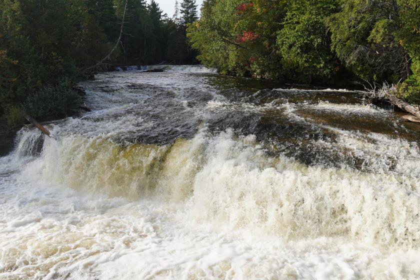
Travis Smola
Almost everyone who has ever visited the U.P. has heard about Tahquamenon Falls. It's the largest and most famous waterfall in the state. And as much as I love Tahquamenon, the lower falls just downriver might be prettier than the upper falls. The nice thing about the lower falls is they cascade in more spots and there are more trails offering more viewing angles and scenic vistas. From the parking area, it's an approximately .40-mile one-way hike to the main viewing areas. However, most people are going to easily burn more boot rubber than that. The Michigan DNR recently added a bridge across the Tahquamenon River to the island, which hosts another half-mile loop.
If that still isn't enough for you, the trail past the cascading waterfalls continues for another 4 miles to the upper falls, so you can easily make this a longer hike if you wish. The trekking is easy around the lower falls, as there is almost no elevation gain, and much of the trail immediately around the falls is boardwalk. I highly recommend getting there first thing in the morning, especially in the summer. That's not just because the early morning light is beautiful, but also because the place can get extremely busy after 10 a.m. In hotter months, many people will use the lower falls as their favorite swimming hole. I highly recommend visiting here in the fall instead. To reach the lower falls, take M-123 west from Paradise about 11 miles, and you can't miss the signs pointing the turnoff for the lower falls.
For more outdoor content from Travis Smola, be sure to follow him on Twitter and Instagram. For original videos, check out his Geocaching and Outdoors with Travis YouTube channels.