When most people plan a trip to Utah, they look to the Big Five: Utah's national parks. And while national parks are well worth a visit, Utah has plenty of other protected lands that are just as gorgeous—and far less crowded. One of my favorites to visit in the fall is Grand Staircase-Escalante in southern Utah, about five hours from both Salt Lake City and Las Vegas.
At 1.9 million acres, Grand Staircase-Escalante National Monument is double the combined land of Utah's five national parks and offers some of the most rugged, beautiful, and remote landscapes in the United States. Within this BLM land, you can explore canyons, cliffs, waterfalls, and ancestral Puebloan dwellings, learn about Native American history and see dinosaur tracks, and take a back entrance into Capitol Reef National Park, should you want to adventure further.
Fall brings cooler temperatures to the Utah desert, as well as gorgeous fall foliage, as the cottonwood leaves turn a gorgeous gold. With plenty of remote corners and scenic dirt roads to take you off the beaten path, Grand Staircase-Escalante is an excellent road trip destination in the southwest this fall.
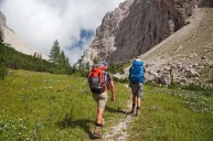
As a seasonal mountain guide with most of the fall season off, I used to drive my van to Grand Staircase from Washington each fall. I've explored most of the nooks and crannies of the national monument, and once spent three weeks backpacking and canyoneering through the canyons.
Here are my favorite roads in the national monument, and my favorite stops along the way.
1. Stock up in Escalante and Boulder
Escalante and Boulder are the two Utah towns closest to Grand Staircase. They're the only places to top up on supplies before heading deeper into the national monument. Escalante has a few small grocery stores and outdoor shops, while Boulder has a wonderful museum on Native American history in the region, the Anasazi State Museum. Pro tip: The restaurant next door, Burr Trail Grill, serves up some of the best grilled trout I've ever had.
If camping or RVing aren't your cup of tea, Escalante and Boulder have some lovely hotels and bed and breakfasts to use as a base camp if you'd prefer to do day trips into the national monument.
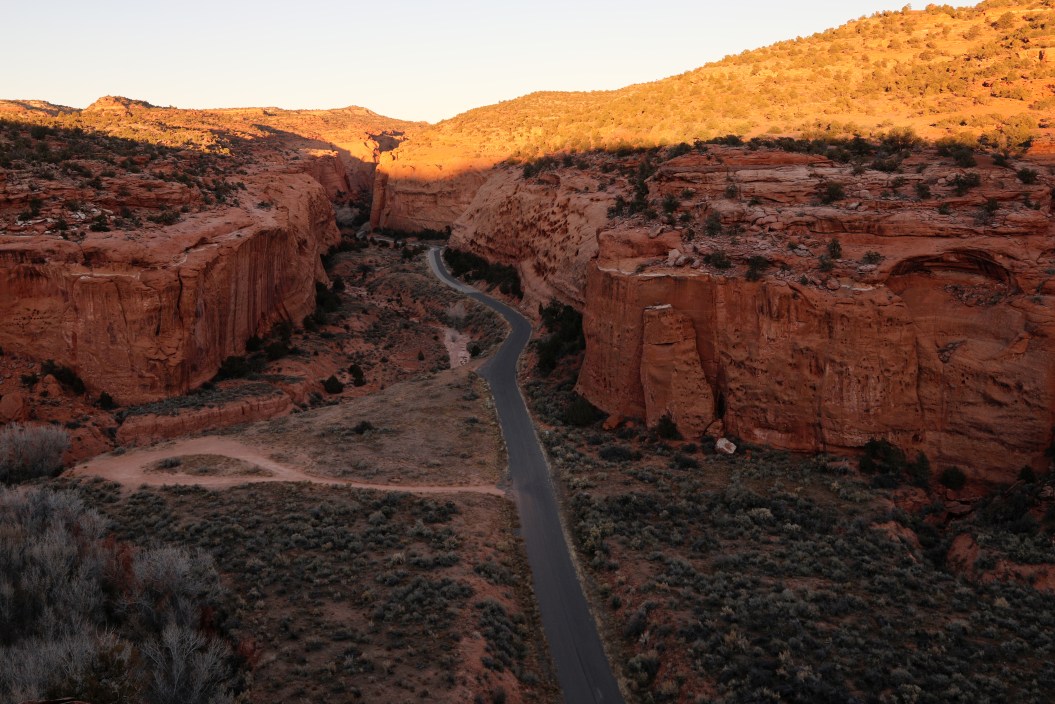
2. Drive the Main Drag: Scenic Byway 12
Scenic Byway 12 is a scenic byway that's also been christened an "all-American road," a distinction that only one-third of America's scenic byways have earned, given to them because the roads offer unique features that can't be found anywhere else. All-American roads are tourist destinations unto themselves, and Scenic Byway 12 has well earned the title.
Scenic Byway 12 is a paved road that cuts through the northern part of Grand Staircase, traveling through both Escalante and Boulder. Along the way, there are plenty of short hiking trails to waterfalls and Ancestral Puebloan pictographs, as well as pullouts to stop and take in the view.
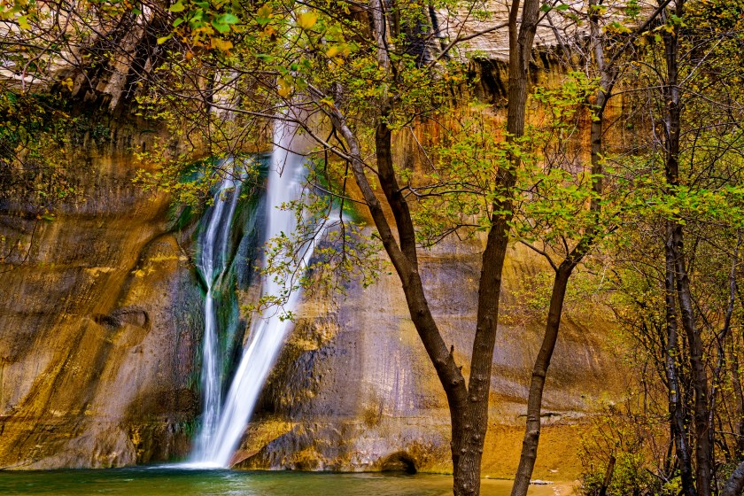
3. Hike Lower Calf Creek Falls
Getty Images, Adventure_Photo
Lower Calf Creek Falls is a beautiful, 6-mile, round-trip hike between Boulder and Escalante. You'll hike through a valley of beautifully colored cliff walls that follow the creek. Along the way, gawk at the ancient pictographs on the walls and stroll across the sandy shores. The trail ends at a 126-foot waterfall, where you can picnic. This is one of the more popular hikes in the area, so get there early to enjoy an empty trail.
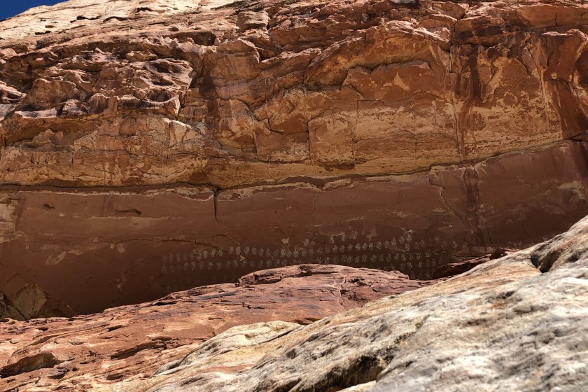
4. Hike 100 Hands Panel and Escalante River Trail
Chelsey Cook for Wide Open Spaces
The 100 Hands Panel is just up the road from the Lower Calf Creek Falls trailhead. A short, mile-long hike brings you to a gorgeous alcove in the cliff above the trail. In the alcove are hundreds of white hand-print pictographs left by the Ancestral Puebloan Native Americans, who lived along the Escalante River for thousands of years. Keep walking along the trail and looking up at the cliff band to see more petroglyphs, which differ from pictographs because they're carved into the rock, rather than painted on.
Nearby, you can also find the trail to hike along the Escalante River, which winds its way through Grand Staircase-Escalante. This portion of the trail is 15 miles long and brings you back to the town of Escalante. Keep an eye out for petroglyphs on the canyon walls along the way.
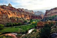
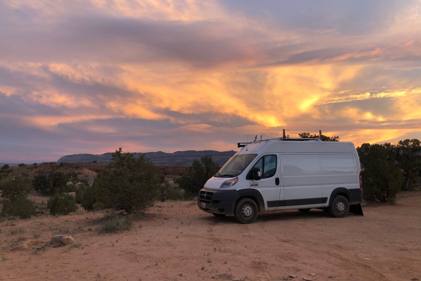
5. Drive and Camp at Hole-in-the-Rock Road
Chelsey Cook for Wide Open Spaces
Hole-in-the-Rock Road originally started as a trail cut into the landscape by Mormons in the late 1800s. Their goal was to connect their settlements in western Utah to the Colorado River (now part of Lake Powell), where they could then ferry across the river and create new settlements in the region east of the river. While putting in the trail itself was tedious, the men of the expedition then spent six weeks chiseling and blasting a path through a steep crevice in the cliffs, i.e., the hole in the rock.
Today, it exists as a 62-mile dirt road that runs through Grand Staircase. While the first half of the road is generally passable by any vehicle, the road can be extremely wash-boarded and tends to degrade along the way. A four-wheel-drive, high-clearance vehicle is recommended if you are going far down, or off, the road. There are numerous dirt roads off of the main road, with canyons, dinosaur footprints, and backcountry hikes to explore.
Grand Staircase-Escalante is managed by the Bureau of Land Management (BLM), and dispersed camping exists along the road. Some of my favorite nights ever have been in the pull-outs along Hole-in-the-Rock Road. Note that these are primitive sites, without hookups or sometimes even toilets. Plan on being self-sufficient.
6. Explore 20 Mile Wash Dinosaur Trackway
Chelsey Cook for Wide Open Spaces
Located about 14 miles down Hole-in-the-Rock Road, the Twenty Mile Wash Dinosaur Trackway is a white bench of rock that once lined the edges of a dinosaur watering hole. Climb up onto the bench and start walking, keeping your eyes peeled for any depressions or darker shadows in the rock. Over 350 individual dinosaur tracks can be found, from plant-eating sauropod tracks to predatory allosaurus tracks.
7. Hike the Golden Cathedral
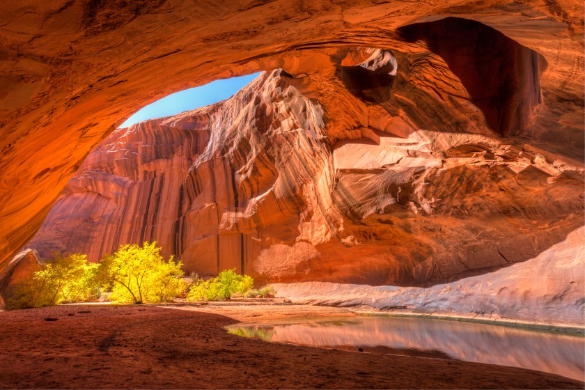
Getty Images, lightphoto
The Golden Cathedral may be the most photographed place in Grand Staircase and with good reason. Located 17 miles down Hole-in-the-Rock, the 9.5-mile, round-trip hike brings you up Neon Canyon, a gorgeous, deep canyon off the Escalante River. The hike requires you to cross the Escalante River a few times, so wear shoes that you don't mind getting wet.
Neon Canyon eventually opens up into an immense, gorgeous grotto of vibrant orange and red sandstone. There is a pool in the grotto and shady trees. The cathedral ceiling hovers high above, with two pour-off holes in the top leading to the upper section of the canyon. For the truly adventurous hikers, book a canyoneering trip down upper Neon Canyon, which will end with you rappelling through one of the pour-off holes into the Golden Cathedral.
8. Hike and Scramble at Peekaboo and Spooky Gulch Canyons
Both Peekaboo and Spooky Gulch are slot canyons: long, narrow channels with sheer rock walls that dominate Grand Staircase-Escalante National Monument. There is a trailhead for the canyons just 26 miles down Hole-in-the-Rock Road, and a three-mile loop connects the two slot canyons, making for the perfect day of hiking exploration.
Slot canyons are essentially adult-sized playgrounds, and this loop has some incredible scrambling and squeezing packed into the three miles. Unlike many slot canyons, neither Peekaboo nor Spooky Gulch require technical gear, just some creativity and playfulness to get through. The sandstone is beautiful, too, and takes a stunning photo.
Spooky Gulch is more narrow than Peekaboo, and because of how tight the canyon can get, it's best for small body types and people who aren't claustrophobic.
9. Drive the Burr Trail Scenic Byway
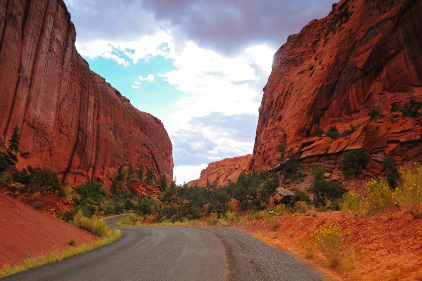
Getty Images, Pedro Carrilho
The Burr Trail Scenic Byway is a 67-mile, mostly dirt road that connects the town of Boulder to the Bullfrog Marina, where travelers can hop a ferry to Bullfrog itself, just outside the Glen Canyon National Recreation Area. The trail was originally developed by John Burr in the late 1800s so he could move his cattle between their summer and winter grazing areas. Now, the scenic road travels through some of the most beautiful areas of Grand Staircase-Escalante, and into Capitol Reef National Park.
Part of the Burr Trail winds through Capitol Reef National Park in a series of switchbacks that aren't suitable for RVs or trailers. But even if you aren't going all the way to Bullfrog Marina, driving the Burr Trail to the border of the national park is well worth the trip.
10. Listen to Singing Canyon
Singing Canyon is located a short 11 miles down the Burr Trail. True to its name, Singing Canyon offers incredible acoustics unlike any place you've been before. If you're a musician with a portable instrument, take advantage of the one-of-a-kind space. And if you're not, simply enjoy the beautiful canyon. You'll be surrounded by 80-foot sandstone walls.
The approach to the canyon is a flat, 10-minute walk, making it accessible for just about anyone.
11. Hike at Waterpocket Fold and Capitol Reef National Park
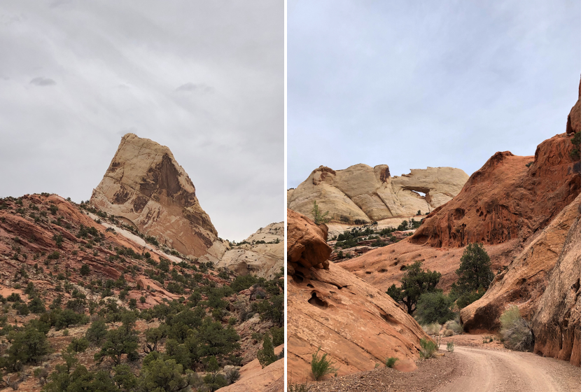
Chelsey Cook for Wide Open Spaces
Where the Burr Trail meets the national park is called the Waterpocket Fold, a beautiful geologic landform that juts out of the desert floor in waves of red, orange, and white sandstone. Lower Muley Twist Canyon cuts lengthwise along the spine of the canyon, and hiking Lower Muley Twist is a must-do. The 14-mile loop trail explores the deep, narrow, and twisting canyon, full of alcoves and hidden corners.
If you have a vehicle capable of making it through the switchbacks, check out Upper Muley Twist Canyon as well.
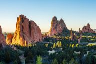
12. Check Out Nearby Destinations
Getty Images, lucky-photographer
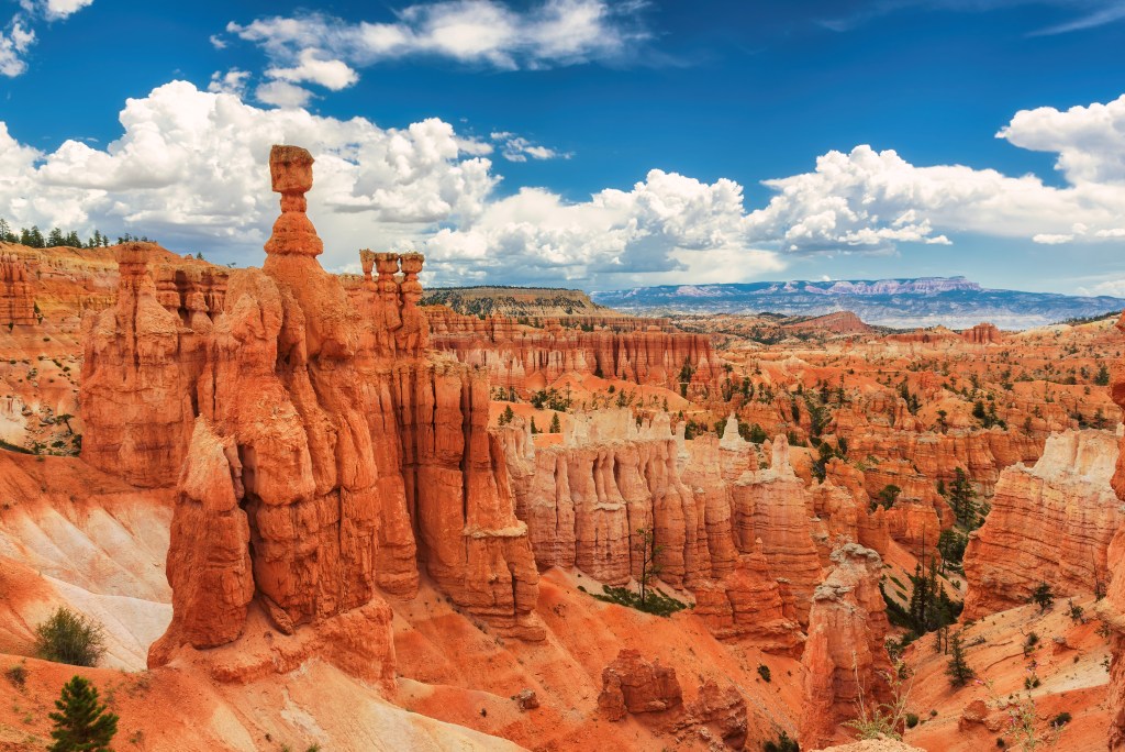
1. Bryce Canyon National Park
Just an hour west of Grand Staircase-Escalante is Bryce Canyon National Park. Famous for its incredible, goblin-like rock formations known as hoodoos, this small national park is well worth a visit. Check out the Queen's Garden trail, or catch the sunrise or sunset from the rim of the canyon.
2. Zion National Park
Two hours west of Grand Staircase-Escalante is Zion National Park. The park is known both for its expansive, 2,000-foot-deep canyon, and its smaller slot canyons. Hike through the narrow passageways of the Narrows, or climb the vertigo-inspiring cliffs of Angels Landing.
3. Kanab
The town of Kanab is two hours south of Grand Staircase-Escalante and just over the border of Arizona. Kanab is a great basecamp for any southern Utah adventure. Make sure to check out the world-famous, no-kill Best Friends Animal Sanctuary, located in a canyon and home to over 1,600 dogs, cats, birds, horses, pigs, and other animals.
Notes On Safely Roadtripping in Utah
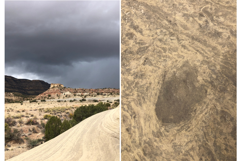
The Grand Staircase-Escalante region is remote, with very little in the way of services, and almost no cell coverage. Before heading out, be sure to have plenty of water (at least 4 liters per person per day). You may also want to pack a satellite phone if you're concerned about being out of touch.
You'll also want to pack for any type of weather—and consult the forecast regularly. Fall nights can easily drop below freezing, and sudden heavy rains can make roads impassable and canyons deadly with flash flooding. Some of the dirt roads can be difficult to drive even in dry weather, and a four-wheel-drive, high-clearance vehicle is highly recommended if you plan to leave the main roads. Before heading out, check out the Escalante Interagency Visitor Center's road reports.
READ MORE: The Ultimate Road Trip Guide: From Las Vegas to Zion National Park