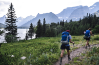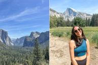
Just a few years ago, my fiancé and I decided that we would visit at least one national park per year. This year, we chose to visit Yosemite National Park, which is undoubtedly one of the best places for hiking in the United States. In addition, the park's diverse trails offer some of the world's most scenic landscapes consisting of plunging waterfalls, deep valleys, and ancient giant sequoias.
Given our shared passion for hiking and appreciation for the outdoors, we knew Yosemite National Park would be perfect for our next hiking adventure. Our visit took place in Yosemite from Aug. 24 to Aug. 30, which is considered warm and dry season.
With that being said, I put together a list of some of the best hiking trails in Yosemite National Park, all of which hold a special place among my personal favorites. Here are the top nine hikes I completed, ranked by difficulty, along with reasons why I believe they're worth visiting.
Easy Hikes In Yosemite
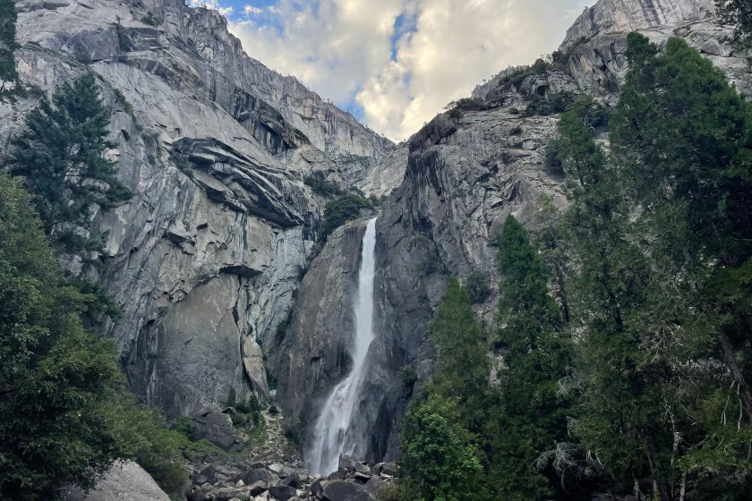
1 of 2: Lower Yosemite Falls Trail
Alyssa Hui for Wide Open Spaces
Quick facts:
- Length: 1.2 miles
- Elevation gain: 55 feet
- Route type: Loop
- Average completion time: 30 minutes
- Best place to access trailhead: Yosemite Village parking areas. Visitors can also ride the free shuttle bus (7 a.m. to 10 p.m.) to Lower Yosemite Fall (shuttle stop No. 6).
The Lower Yosemite Falls trail, in Yosemite Valley, is a short and relatively easy hike that remains open year-round. It is a 1.2-mile loop that can take on average anywhere from 25 to 30 minutes to complete, but you may find yourself spending more time on the trail itself because there are many points along the way where you can stop and take pictures or rest to admire the lower falls. (P.S.: Be prepared to make frequent stops on other trails, too — it's rare not to encounter jaw-dropping views throughout Yosemite.)
The mostly flat trail will take visitors through a full and lush forest that leads to the base of the iconic Lower Yosemite Falls. There's a view of the Upper Falls from the trail as well. As you continue on the hike, you'll come across a section just past a bridge (which is not a part of the trail) offering hikers the chance to venture closer to the lower falls. Plus, the waterfall creates a mist that covers the surrounding area, which provides a cool sense of relief on warm days. Depending on the time of day, you may see families and other individuals swimming and enjoying the water. If you decide to get closer, just be aware the rocks and surrounding terrain can be slippery, wet, and sharp.
Although the Lower Yosemite Falls Trail can get fairly crowded, it is the best spot to get an up-and-close view of the Lower Falls. The trail is also easy-going and accessible, making it kid- and dog-friendly. Whether you are traveling with a large group or are pressed for time, this is the perfect hike that still allows you to soak in the views of Yosemite Valley.
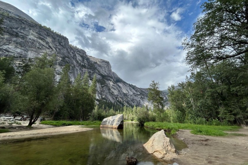
2 of 2: Mirror Lake via Valley Loop Trail
Alyssa Hui for Wide Open Spaces
Quick facts:
- Length: 4.4 miles
- Elevation gain: 301 feet
- Route type: Loop
- Average completion time: 1 hour and 34 minutes
- Best place to access trailhead: Curry Village; however, hikers can access the trail by parking anywhere in eastern Yosemite Valley and taking the free shuttle bus to Mirror Lake (shuttle stop No. 17).
The Mirror Lake via Valley Loop Trail is a great, easy day hike that takes you through the heart of the valley. Even though the trail is 4.4 miles long, it is straightforward and practically flat, making it a good choice for families, children, large groups, and even advanced hikers. Just note that dogs are not allowed on the trail.
The best part of the hike is being able to see everything from towering cliffs to the iconic Half Dome, and Mirror Lake, which is a clear body of water that perfectly reflects the surrounding granite landscape. If you visit the park during the summer, pack a swimsuit, because you can take a dip in the lake as a way to cool off.
Since Mirror Lake is a popular area for hikers, runners, tourists, and families, you can expect some parts of the trail to get crowded. During my trip, I noticed it was most crowded at the start and end of the hike but thinned out in the middle. Keep in mind this trail winds through dense forests, which means you may encounter a fair share of gnats and mosquitoes along the way. If you plan to complete this hike, pack mosquito repellent, opt for lightweight and long-sleeved clothing, and consider wearing a face net for added protection and comfort.
Moderate Hikes In Yosemite
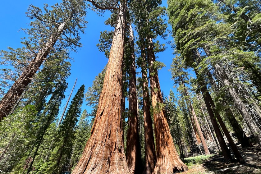
1 of 5: Mariposa Grove of Giant Sequoias Trail
Alyssa Hui for Wide Open Spaces
Quick facts:
- Length: 6.7 miles
- Elevation gain: 1,217 feet
- Route type: Out and back
- Average completion time: 3 hours 12 minutes
- Best place to access trailhead: Mariposa Grove Welcome Area, which has about 300 parking spots. There is also a free shuttle that operates from March to November to Mariposa Grove.
If you want to see some of the largest and most ancient trees on Earth, look no further than the Mariposa Grove of Giant Sequoias Trail. Although this trail is 6.7 miles long, it does not disappoint. You'll hike past and see some of the most iconic and notable sequoias—including the Bachelor and Three Graces, Faithful Couple, Clothespin Tree, and California Tunnel Tree. You'll also see the 3,000-year-old Grizzly Giant Tree (my personal favorite), which stands 209 feet tall and a whopping 96 feet in circumference at its base. All of the sequoias are easily some of the coolest trees I've seen in my life—and I'm sure once you see them, too, you'll also be amazed!
The trail is gentle and well-maintained the whole way and runs mostly on a flat and wide surface—so you don't have to worry about stepping on rocks or uneven footing. While you will gain around 1,217 feet of elevation, it is spread evenly over the 3.8-mile ascent, with no steep or difficult sections. (Which basically means you'll hardly feel the elevation gain.) Toward the top third part of the trail, you'll reach a section that is the most dense, which contains the most sequoias. You will also want to make it to the top of Wawona Point, where the views of the park are just stunning. When I reached the top, I found a shaded spot with my fiancé and enjoyed lunch and the spectacular view.
You can expect to see a lot of people during the first mile or two, but it really thins out shortly after, especially once you pass the Clothespin tree. If you don't want to do the full hike, you can do the Grizzly Giant Loop, which is only 2 miles. You'll still be able to see some of the notable trees mentioned earlier, including Bachelor and Three Graces, California Tunnel Tree and, of course, Grizzly Giant.
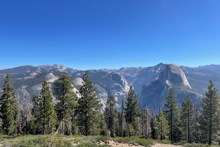
2 of 5: Glacier Point to Union Point
Alyssa Hui for Wide Open Spaces
Quick facts:
- Length: 3.8 miles
- Elevation gain: 1,151 feet
- Route type: Out and back
- Average completion time: 2 hours and 18 minutes
- Best place to access trailhead: Glacier Point Road
The Glacier Point to Union Point trail is a 3.8-mile out-and-back route that is considered moderately challenging. Hikers will tackle long switchbacks that run through forests, meadows, and rocky terrain. The first part of the hike is mostly downhill and at some points can be steep; however, it levels out as you progress. I recommend using trekking poles if you have them during the first part to take some load off of your joints, including the knees.
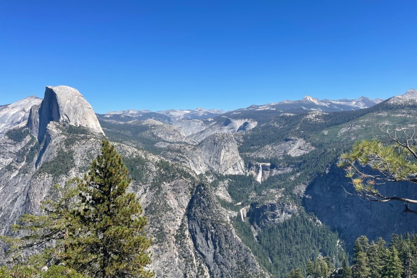
During the second half of the trail, which is entirely uphill, hikers will gain around 1,151 feet of elevation, making it moderate in terms of difficulty. If you are not a frequent hiker, this trail can feel hard—and, in some cases, it may feel like you're climbing a StairMaster. Although the hike is moderately challenging, you get terrific and closer views of Upper and Lower Yosemite Falls and Half Dome. There are also parts along the trail where you can stop for panoramic shots of the valley.
An important note: The viewing area is quite small once you reach Union Point. If it's busy, be prepared to wait a few minutes before stopping to admire the view or take any pictures. Luckily, when my fiancé and I reached the halfway point, only one other couple was there; and once they left, we were able to sit on a rock, enjoy the view, and eat lunch. In addition, the trail is not well-shaded in certain areas including at Union Point, so be sure to wear protective clothing and apply sunscreen.
Once you complete the hike, grab some ice cream at the Glacier Point Gift Shop and Snack Stand and enjoy the panoramic view of Yosemite Valley, Yosemite Falls, El Capitan, and Half Dome. If you don't feel like hiking the full trail, you can still get these stunning views at the Glacier Point overlook.
3 of 5: Sentinel Dome and Taft Point Loop
Alyssa Hui for Wide Open Spaces
Quick facts:
- Length: 5.1 miles
- Elevation gain: 1,105 feet
- Route type: Loop
- Average completion time: 2 hours and 38 minutes
- Best place to access trailhead: Sentinel Trailhead (about 2.2 miles from the end of Glacier Point Road)
The Sentinel Dome and Taft Point Loop 5.1-mile trail is the best hike for those who are looking to see a variety of things during their time in Yosemite. My fiancé and I did the trail clockwise and completed the Taft Point Loop first, then hiked to Sentinel Dome to limit the amount of downhill we encountered. We also just wanted to end the trail at the Dome; but, of course, you can choose to complete the trail in whatever order you think is best.
If you start the trail by doing the Taft Point Loop first, you'll begin the hike mostly immersed in the forest. You'll see a ton of pine trees, ferns, and some wildlife such as deer and squirrels. We did this trail in the morning, so walking through the forest felt extremely cool, calm, and peaceful. When we reached the end of Taft Point, it wasn't crowded, which gave us plenty of time to enjoy views of Yosemite Valley, El Capitan, and Yosemite Falls. In addition, because it wasn't packed with other people yet, we took our time taking pictures safely by the edge of the rocks. Of course, use common sense and caution when hiking here, and stay a safe distance away from the edge.
As you continue on the trail to Sentinel Dome, you'll get unbelievable and panoramic views of the valley. You'll see everything including Half Dome, North Dome, Basket Dome, the Upper Falls, and Nevada Falls along the way. The most demanding part of the trail is hiking up Sentinel Dome itself because this stretch features prolonged and sustained elevation gain. (Just imagine walking on the treadmill at its highest elevation setting. Yes, it will burn.)
You'll likely need to stop a few times to catch your breath; but once you make it to the top, you'll get unbeatable 360-degree views of Yosemite. What I love most about this hike is that when you reach the summit of Sentinel Dome, no matter where you choose to rest or stand, you're treated to a complete array of breathtaking and spectacular views from all directions. While it can get crowded, the top of the dome is quite large, allowing enough space for everyone to sit and move around. This trail is by far one of my favorites in Yosemite—and I'm sure if you choose to hike it, too, you won't be disappointed.
4 of 5: Illilouette Falls via Panorama Trail
Quick facts:
- Length: 5.2 miles
- Elevation gain: 1,430 feet
- Route type: Out and back
- Average completion time: 3 hours
- Best place to access trailhead: Glacier Point Road
If you have already seen some of the more notable falls in Yosemite National Park including Yosemite, Sentinel, Nevada, and Vernal, you may want to check out Illilouette Falls. This waterfall is 370 feet and flows pretty much all year round, with its peak flow occurring in late May. What makes this waterfall unique is that it is not visible from any road, and the only way to see it is by hiking. The best place to see Illilouette Falls is on the Panorama Trail, only a few miles from Glacier Point.
This moderately challenging hike offers extensive views of iconic Yosemite landmarks such as Half Dome, Nevada Falls, and the High Sierra Peaks. The trail also consists of a diverse range of terrain, such as wooded areas, rocky slopes, and open meadows. The entire first half of the trail takes place over a gradual decline and downhill—but if I'm being honest, it does feel very long. Once you reach the half point, you'll be very close to the falls, but just be aware you won't have the best view of it. You will, however, have a terrific and close view of Illilouette Creek, which makes for a perfect photo opportunity.
The second half of the trail is entirely uphill and on a constant incline, so it can be difficult and taxing for some, especially in hot weather. Although the hike is more challenging on the way back up, it does go by faster compared to the hike down. Keep in mind that the trail lacks significant shade, so it's important to wear plenty of sunscreen and protective clothing. You may also encounter sections with fallen trees and slightly overgrown bushes. Despite these challenges, the trail truly allows you to feel deep in the mountains and mountainous terrain. What's even better is that there are practically no crowds, ensuring that you can enjoy the entire hike in peace and quiet.
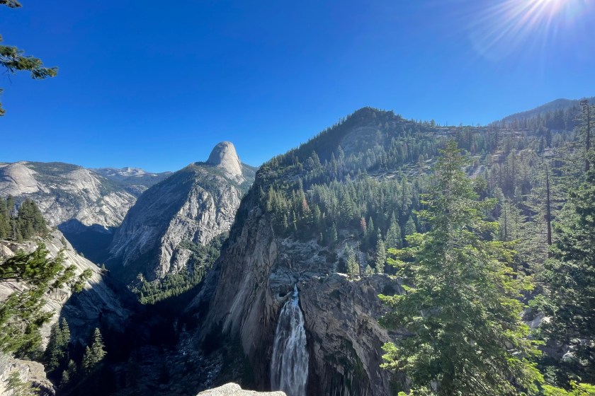
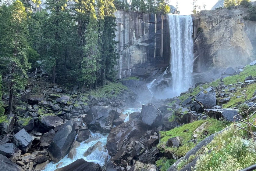
5 of 5: Vernal Falls and Clark Point via Mist and John Muir Loop
Alyssa Hui for Wide Open Spaces
Quick facts:
- Length: 4.5 miles
- Elevation gain: 1,614 feet
- Route type: Loop
- Average completion time: 3 hours
- Best place to access trailhead: Curry Village. Visitors can also take the shuttle to Happy Isles (shuttle stop No. 16). There is no parking in the immediate area.
If there's any moderate hike you must do, it's the Vernal Falls and Clark Point via Mist and John Muir Loop. I'm not going to lie, this trail is certainly challenging and strenuous at points. From the start, there is a decent amount of elevation change that not everyone can tackle. Within the first mile, you gain about 700 feet of elevation; and as you continue, you gain another 1,000 feet.
Despite the burn you'll likely feel in your legs, you will get to witness breathtaking and up-close views of Vernal Falls, which plunge 317 feet into the Merced River. But the best part is climbing up the steps to Vernal Falls and feeling the mist from the Falls splash onto your face and body—much-needed when hiking in hot and sunny weather! Throughout the trail, you will also see lush forests, granite cliffs, Nevada Falls, and Liberty Cap.
Although the trail can get very busy, especially at the start and at the steps ascending to Vernal Falls, I believe it's a must-do hike when visiting Yosemite National Park. The views are undeniably stunning, and there's no other trail experience that can compare to hiking this route. On average, you can expect to be on this trail for 3 hours, but it can be more if you stop for pictures and snack breaks. I recommend descending the hike via the John Muir Trail versus back down the Mist Trail to avoid going down any slick and wet steps. Also, keep in mind that the Mist Trail is closed on weekdays from 7 a.m. to 3:30 p.m., but be sure to check ahead of time for any potential trail closures.
Difficult Hikes In Yosemite
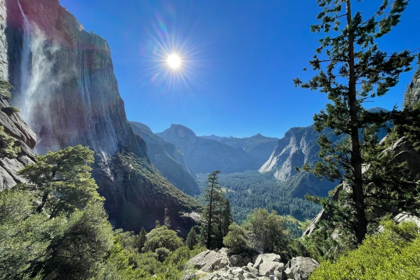
1 of 2: Upper Yosemite Falls Trail
Alyssa Hui for Wide Open Spaces
Quick facts:
- Length: 6.6 miles
- Elevation gain: 3,254 feet
- Route type: Out and back
- Average completion time: 5 hours and 21 minutes
- Best place to access trailhead: Yosemite Valley Lodge parking lot or hikers can take the free shuttle to Yosemite Valley Lodge/Yosemite Falls Parking (shuttle stop No. 7).
The Upper Yosemite Falls Trail is a brutal, 6.6-mile hike that features a total of 3,254 feet of elevation. The terrain is mostly unpaved, which means you'll be hiking on uneven rocks and stones for several hours. In addition to stepping on uneven and rocky terrain, you're constantly gaining elevation via switchbacks, making the hike not only challenging uphill but steep as you make your way back down to the end of the trail.
Despite the strenuous climb, the views throughout the trail are truly amazing and breathtaking, especially as you get closer to the base of the upper falls. I think the best view is about 1.5 to 2 miles in, because you'll have a view of Half Dome and the Falls in the same shot. Once you reach the top, you'll get stunning views of the whole valley unlike anywhere else in the park. You'll truly feel on top of the world (at least I did once I made it up). Enjoy your lunch once you get there and soak it all in.
My biggest tip before hiking this trail is to make sure you're wearing comfortable and sturdy hiking shoes because the terrain is so rocky and uneven. I slipped about three times on the way down despite wearing hiking boots with good grip. Just remember to take the downhill slowly and at your own pace. Besides proper hiking shoes, pack lots of water and consider using hiking poles to alleviate stress on your legs and knees during the descent. I also recommend doing this climb early in the morning since the trail is completely exposed.
If you don't have time or aren't quite ready to hike all the way to Upper Yosemite Falls, consider hiking to Columbia Rock, which is only 2 miles. This trail is super steep and features a ton of switchbacks, but you will be rewarded with stunning views into the Valley.
2 of 2: Half Dome via the John Muir Trail (JMT)
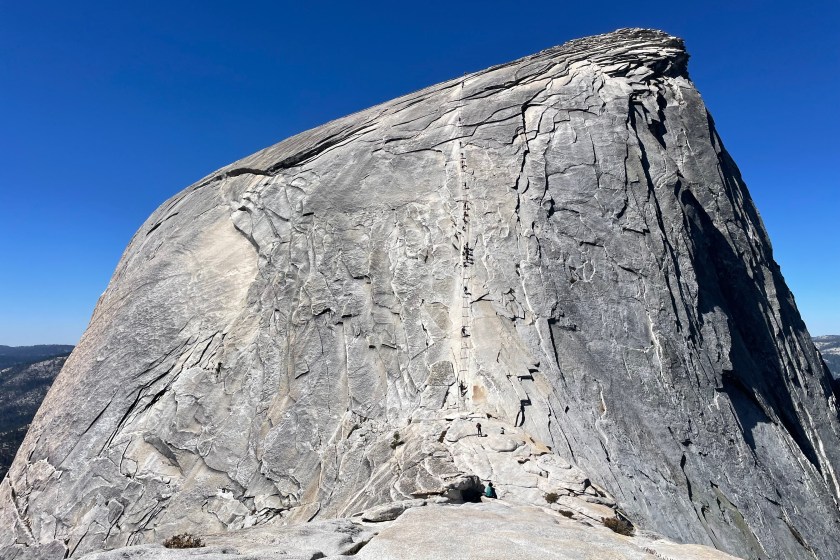
Alyssa Hui for Wide Open Spaces
Quick facts:
- Length: 16.5 miles
- Elevation gain: 5,305 feet
- Route type: Out and back
- Average completion time: 10 to 12 hours
- Best place to access trailhead: Yosemite Valley Trailhead Parking. Hikers can also take the shuttle to Happy Isles (shuttle stop No. 16).
Half Dome via the John Muir Trail is an extremely difficult hike and it is certainly not for everyone, especially those who are not in good physical shape or for those who don't come well-prepared. Throughout the 16.5-mile hike, you'll gain over 5,000 feet of elevation. As you continue the hike to Half Dome, you'll reach even higher altitudes, particularly since Yosemite Valley is already at a relatively high elevation.
Most people should plan to spend the whole day doing this climb unless they are in great physical shape. It can take anywhere from 10 to 12 hours to complete and is as close to a marathon as a day hike. Once you reach the base of the Dome, which is about 7.7 miles in, a park ranger will check to ensure you have a hiking permit. I think the most challenging part of the hike is right after the checkpoint, because you gain 886 feet of elevation in 0.5 miles from the checkpoint to the summit of Half Dome. Because of how steep this section is, you can expect to stop several times before reaching the cables to catch your breath.
When you reach the cables, you'll need to rely on your upper body strength to pull yourself up. If you can't do one pull-up, you might struggle during this part of the climb. Plus, gloves with a good grip are a must. (No gloves = no climb.) If you are afraid of heights, I don't recommend climbing up the cables, especially since it can get congested and backed up with foot traffic.
Once you reach the summit of Half Dome, you'll get breathtaking, 360-degree views of Yosemite Valley and the High Sierra. You'll also be able to see the entire length of the valley with its forests and meadows. It is truly one of the most iconic and inspiring aspects of reaching Half Dome's summit. My fiancé and I spent about an hour at the summit fueling and hydrating our bodies. Plus, we did a bit of exploring at the top of the Dome since it is so large and spacious.
Although the descent is way easier, it is a long way back down to the start of the trailhead. Be sure to take plenty of stops, eat snacks, and drink water. Nevada Falls serves as a good rest stop, and it also features a close-up view of Liberty Cap. I would recommend packing a water filter so you can filter clean drinking water at various points, including at Nevada Falls.
As someone who frequently goes on hikes and is physically active, I would say Half Dome is the most challenging hike I've done in my life. Despite how difficult it was, I don't regret doing it. Overall, it was such a fun, unique, challenging, and rewarding adventure, especially since I got to experience the iconic formation up-close. Besides the spectacular views, hiking Half Dome allows you to bond with other hikers on the trail, which is something you don't get to experience on any other trail. You get to encourage and motivate other hikers and climbers, especially in the cables section. It's a climb you can't experience anywhere else in the world.
Frequently Asked Questions
Vernal Falls via the Mist Trail is the most popular hike in Yosemite National Park. On the Mist Trail, hikers get access to jaw-dropping and up-close views of Vernal Fall unlike anywhere else in the park. You can get so close to the waterfall that you can feel the mist on your skin. While the trail is moderately strenuous, it remains accessible to a wide range of hikers including beginners, large groups, and families. There are also many excellent photo opportunities by the Falls and along the trail as well.
I believe Sentinel Dome and Taft Point Loop is the most picturesque trail in the park. Hikers get a diverse range of landscapes and stunning viewpoints all along the trail, including iconic landmarks like El Capitan, Yosemite Falls, and Half Dome. Plus, once you're on the summit of Sentinel Dome, you get stunning 360-degree views of the entire valley, which you can't get anywhere else in the park.
The best trail to see El Capitan is the West Valley Loop Trail which is a 6.2-mile loop near Yosemite Valley. The trail is relatively flat and you get stunning views of El Capitan along with Ribbon and Bridalveil Falls. Depending on the season, be aware some parts of this trail may be flooded.
READ MORE: 9 Visual Reasons Why Everyone Should See the National Park at Least Once